GNSS Surveyor: Achieving High Accuracy
Achieving high accuracy with a Bad Elf GNSS Surveyor (BE-GPS-3300)
The Bad Elf GNSS Surveyor (BE-GPS-3300) is capable of achieving positional accuracies of one meter or less when setup and configured properly. This tutorial is a guide to ensuring you have the correct configuration for the GNSS Surveyor. Examples are included that show real-world troubleshooting. Completing this checklist provides you the knowledge of how to verify your GNSS Surveyor is configured to maximize accuracy.
Verify your configuration
In this section we take you through the steps of how to use the Bad Elf iOS application to verify your receiver is properly configured. During this process, we will ensure that your Bad Elf GNSS Surveyor (BE-GPS-3300) is configured properly to use SBAS and PPP (Precise Point Positioning).
Start the Bad Elf iOS application and click on the line titled “Bad Elf GNSS Surveyor”
Scroll all the way to the bottom of the page and click on “Advanced Settings”
Verify that SBAS/WAAS/EGNOS is set to “Enabled”
Scroll down, on the same page, all the way to the bottom and confirm under “GPS engine” is set to “GPS/QZSS/SBAS/PPP”
Confirming your configuration
In this section we confirm that the settings changes have taken effect properly. Below are side-by-side examples, from the field, that demonstrate less than optimal and optimal configurations. Explanation is provided such that you can quickly assess when your GNSS Surveyor is performing optimally.
Verifying fix type on the GNSS Surveyor
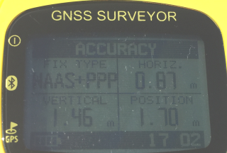
Using the GPS button on the bottom left of the GNSS Surveyor, cycle through the menus until you reach a menu that has “Fix Type” in the upper left corner.
3D only solution | WAAS+PPP solution |
 | |
In this case only a 3D solution is provided. This Fix Type indicates that SBAS satellites may not have been acquired yet and as such the GNSS Surveyor is not achieving maximum accuracy. | The Fix Type indicates WAAS+PPP which means the GNSS Surveyor is configured properly, is receiving SBAS, and PPP is active. Leaving the device stationary and unobstructed will further help maximize accuracy. |
Verifying satellite visibility
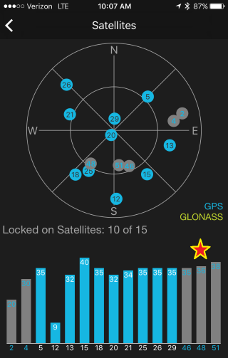
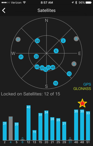
The Bad Elf app has a satellite screen that shows the accuracy measures, location of satellites, and satellite acquisition state.
- Gray bars indicate that the GNSS Surveyor can hear the satellite but has not acquired the satellite.
- Blue bars indicate the GNSS Surveyor has a lock on the numbered satellite.
- The height of the bars indicate signal strength (higher is better)
3D only solution | SBAS solution |
 |  |
In this case only a 3D solution is provided. This Fix Type indicates that SBAS satellites are in acquisition mode may not have been acquired yet and as such the GNSS Surveyor can’t achieve maximum accuracy. | The Fix Type indicates that the GNSS Surveyor has acquired a lock on all three SBAS satellites and therefore can improve its accuracy with these corrections. Only one of the three is required; although it doesn’t hurt to have two or more. |
this example is applicable to North America. Typically one will see the last three SBAS satellites on the right of the signal strength bars | Now that SBAS is acquired, the GNSS Surveyor will being using PPP to improve the stationary position of the receiver. |
For assistance, please contact our support team via support@bad-elf.com.
Related Articles
GNSS Surveyor: Collecting Raw Data with the Bad Elf App
Collecting raw data with the Bad Elf app Raw logging is a feature unique to the Bad Elf GNSS Surveyor. There are two primary purposes for this capability as listed below: To collect mixed-mode NMEA/UBX files directly from the internal GPS chipset To ...Collecting Raw Data With The Bad Elf App
Collecting Raw Data With The Bad Elf App Raw logging is a feature unique to the Bad Elf GNSS Surveyor. There are two primary purposes for this capability as listed below: To collect mixed-mode NMEA/UBX files directly from the internal GPS chipset To ...Accuracy Study
Accuracy Study During the fall of 2016, Bad Elf commissioned a research report to test the accuracy of a Bad Elf GNSS Surveyor. The goal of this project was to determine if Bad Elf’s Bluetooth GPS receiver can produce consistent results at a 1-meter ...Best Practices: Field Data Collection
Legacy Content: This article references our end of life product. For recommended product alternatives, see Choosing the Right GPS/GNSS Receiver for Your Work → Field Data Collection Best Practices What do good field techniques mean? GPS receivers ...Offloading Raw Data Logs From The Bad Elf App
Legacy Content: This article references our end of life product. For up to date workflows, see Bad Elf Flex: Collecting Data with RINEX → Bad Elf Bluetooth GPS receivers can produce Raw Data logs that contain the information required for ...